GEOMERGE
ABOUT GEOMERGE
GeoMerge is a robust, yet simple, and most of all, reliable software for ensuring that your data synchronizations are done accurately and quickly.
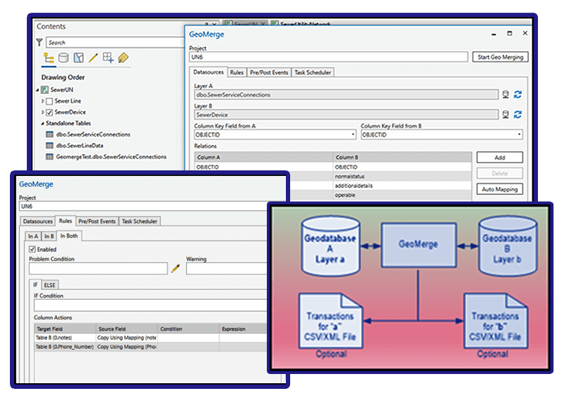
GeoMerge is an add-in to ArcGIS Pro programmatically synchronizing two layers/tables using rule-based instructions. GeoMerge uses the user-defined rules when synchronizing the data to resolve the conflicts. This allows for a flexible configuration so the end-user can identify the conditions under which a record is updated, inserted, or removed from the destination.
GeoMerge includes comprehensive error handling and reporting, which allows checking the status of the individual runs. The log file resulting from the GeoMerge operation is available for inspection and can be automatically emailed to the administrator monitoring the GeoMerge operation.
GeoMerge includes support for the following source or destinations:
-
- Enterprise geodatabase
- File geodatabase
- OLEDB (SQL, Oracle, DB2)
- SQLite – Including Mobile GDB
- Feature service – Including branch versioning
- Shapefile
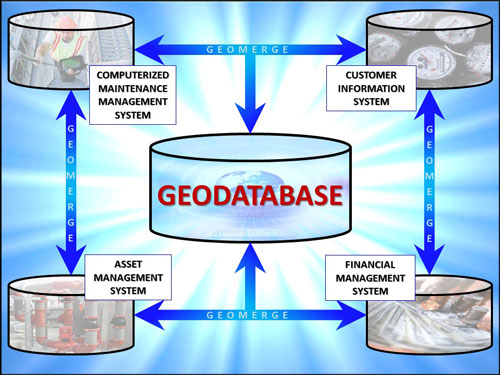
GeoMerge is an ideal tool to maintain a geodatabase synchronized with another geodatabase, an external spatial (e.g., SQL Spatial), or a non-spatial database (Oracle table).
KEY PRODUCT HIGHLIGHTS
Merge Data between Geodatabases & Tabular Databases

Simplify Maintaining your Most Up-To-Date Data Against External Sources

Captures & Reports Results for Every Execution

Maintain & Keep Your Utility Network Databases Up-To-Date
Supports a Variety of Source & Destination Formats

Can be used by DBAs, GIS Teams, Asset Managers & More

Use Rules to Implement a Complex Data Merging Scenario

Run Batch Merges Operations on Schedule
CONTACT US
Please call (949) 540-6400 or reach out to us via our CONTACT PAGE to get more information on GEOMERGE or any of our other software products.
ABOUT US
![]()
SPATIAL WAVE provides utility and municipal organizations both large and small with solutions that are used daily to improve the quality of life of their customers.
CONTACT INFO
• CALL: 949.540.6400
• FAX: 949.586.8141
MAIN LOCATION
23461 S. Pointe Drive, Suite 300
Laguna Hills, CA 92653
